Alice's Tour Pictures for Boston Topographical History Course

Landmaking
Tours
Central Waterfront
Bulfinch Triangle
West End
Beacon Hill Flat
Back Bay & South End
Fens, Fenway & Bay State Rd.
South Cove
South Bay & South End
South Boston
Dorchester
East Boston
Charlestown
The
Fens, Fenway and Bay State RoadToday's Fens was a marshy area where the Muddy River and Stony Brook converged into the Charles River estuary. Frederick Law Olmsted designed the Fens as a storm overflow area camouflaged as a park, instead of originally planned straight-side reservoir. Construction of the Fens encouraged filling and development of the adjacent areas. Many cultural and educational institutions would take up residence on these new-made lands in the late-nineteenth and the early twentieth century.
Streets comprising this area include: Charlesgate East and West; Fenway and Riverway; Brookline, Commonwealth, Huntington and Longwood Avenues; Bay State Road; Back, Beacon, Ipswich, Lansdowne, and Parker Streets. Major landmarks and buildings in this area and its vicinity include the Museum of Fine Arts, Fenway Park, Boston Latin School, the Longwood Medical area, the Isabella Stewart Gardner Museum, Boston University, Massachusetts College of Art, the Wentworth Institute.
Back Street
I am the sole person responsible for the content of this photo gallery site. Please contact me if I have made any mistakes in citing a photo's location or detail.
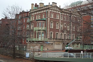
Back Street
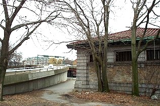
This building on the corner of Back Street near Charlesgate West sits atop
the seawall that demarks the original shoreline.
Bay State Road
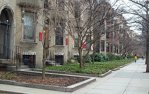
Boston University on
Bay State Road
Originally row house apartments for the well-to-do, the red signs on these
buildings on Bay State Road identify them as student residences or offices
for nearby Boston University.
Beacon Street
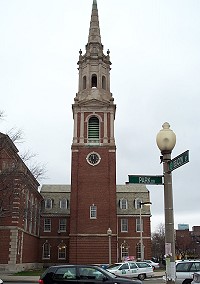
Church at Beacon
Street and Park Drive
The Ruggles Street Church by Ralph Adams Cram stands at this intersection,
known as the Audobon Circle which was filled in during the early 1890s.
Fens near Boylston Street
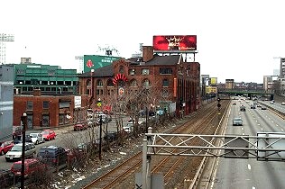
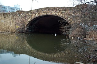
Bridge at Boylston
Street
From this bridge on Boylston Street, the original tracks of the Boston and
Albany Railroad are visible beside the Mass Pike. The green upper deck
of Fenway Park can be seen on the left side of this view.
Fire Department
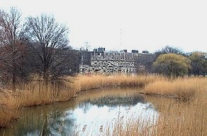
Building among the phragmites
Phragmites have overgrown the shores of the Fens and block the view to the
water with their reed stalks, which can grow to six meters high. The
odd-colored training building for Boston firefighters adds to the
strangeness of this water view.
The Bridge at Boylston
Street
Trash is visible in the water and is another symptom of the lack of
maintenance of the Fens.
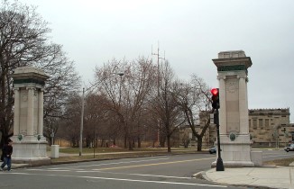
Westland Avenue
Gateway
This gateway to the south of the Boylston Street entrance marks the Westland
Avenue entrance to the Fens. The Boston Fire Department's training building
stands just beyond this entrance in the right of this camera shot.
Fens at Charlesgate
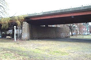
Beacon Street Entrance
The footbridge built as part of the 1909 widening of the Embankment stood
near the Beacon Street entrance to the Fens and is now surrounded by the
Charlesgate ramps and the Bowker Overpass. The Fens gatehouse can be
glimpsed on the photo's right side.
Fens Gatehouse
Built in 1909 at the connection between the Stony Brook and the Boston
Marginal Conduits, this gatehouse is now land-locked by the widening of
Esplanade in the 1950's.
A Wall Alone
Standing alone under the Charlesgate flyover, this wall no longer has a
purpose in today's Fens.
The Fenway
Forsyth Dental
Infirmary
Listed in the Register of National Historic Places, this building was built
in 1915 to offer dental services to the children of the poor in Boston.
Its classical design is typical of buildings with institutional or service
functions during the early twentieth century.
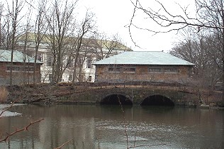
Stony Brook Gatehouses
These gatehouses along the Fenway used to control overflow from the Stony
Brook conduit and can be seen from the shoreline near the War Memorials.
The Forsyth Dental Infirmary is in the background.
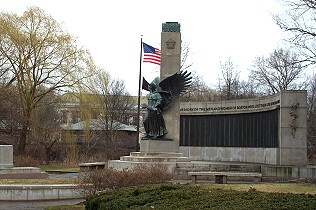
War Memorial
The Forsyth Dental Infirmary and one of the Stony Brook gatehouses can be
seen behind this memorial to the Massachusetts dead of World War II located
near the rose garden section of the Fens.
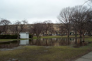
Flooding near War
Memorial
Heavy spring rains the day before this shot was taken flooded this area of
the Fens near the War Memorial and illustrate the ongoing problem of
maintaining water levels in the Fens area.
Gainsborough Street
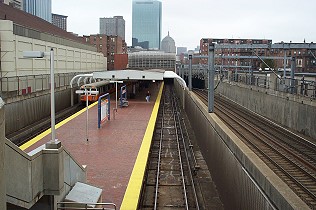
Site of Baldwin's Mill
A block away from the New England Conservatory of Music and its Jordan Hall
at the end of Gainsborough Street, the Orange Line's Massachusetts Avenue
station stands at the 1825 site of Baldwin's Mill.
Hemenway Street
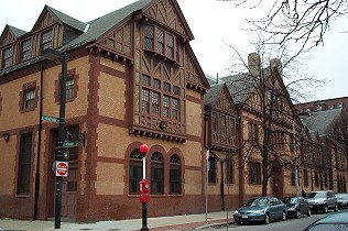
Riding School Building
This 1892 Queen Anne-style building designed by Willard Sears was a private
riding club and school for prominent Bostonians. It now serves as a tennis
and badminton club, with some spaces converted for residences.
Longwood Avenue
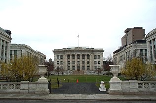
Harvard Medical School
This complex of medical buildings was completed in 1907 and sits on the
original land side of Longwood Avenue at the head of Avenue Louis Pasteur.
The former marsh areas of Longwood Avenue behind the camera position were
filled in 1885.

Vanderbilt Hall
Occupying the lot formerly designated as "No. 650" in the Fuller and Whitney
plans, Vanderbilt Hall is an active student residence and center for the
Harvard Medical School.
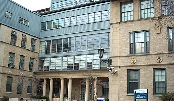
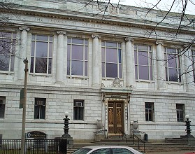
Boston Lying-in
Hospital
Established in 1832, the Boston Lying-In Hospital completed this Longwood
Medical area building in 1922. Today, it is part of the Brigham and Women's
Hospital, an affiliated teaching hospital of the Harvard Medical School.
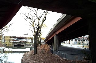
The Muddy River
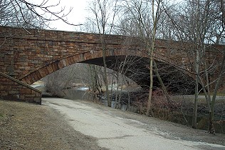
Overpass at Muddy
River
Looking northward, Longwood Avenue passes over the Muddy River near the
Riverway and the Longwood Medical area.
Remains of Muddy River
Boat Dock
The remains of wooden pilings can be seen along the shore of the Muddy River
near the Longwood Avenue stop on the Riverside branch of the MBTA's Green
Line.
Parker Street
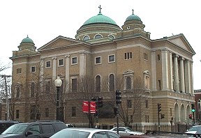
Greek Cathedral Church
Evangelismos
This Greek Orthodox Church stands at Parker and Ruggles Streets. The
ropewalks of the Sewall & Day Cordage Co. stood behind this camera position
and a canal ran further to the right of this view.
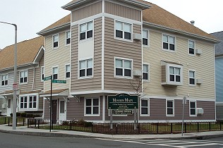
Mission Housing
Complex
An early tide mill once stood here at the intersection of Parker and Ward
Streets, which is now a "corner" of the Mission Hill housing community.
St. Mary's Street
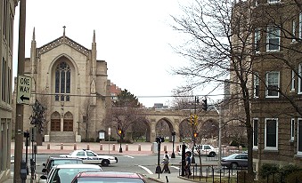
B.U.'s Marsh Chapel
Following St. Mary's Street from the Audobon Circle, B.U.'s signature
chapel--another designed by Ralph Adams Cram--stands at the street's end on
Commonwealth Avenue.
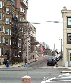
St. Mary's Street
Bridge
A view of St. Mary's Street Bridge from in front of Marsh Chapel. Just
before the bridge over the Mass Pike, the university's Photonic Center can
be see on the left.
© 2004 Alice Kane